Sunshine is delicious, rain is refreshing, wind braces us up, snow is exhilarating; there is really no such thing as bad weather, only different kinds of good weather. ~John Ruskin

Thursday, December 14, 2017

Climate Change in Modern Times

Climate change is a phenomenon that has been present on earth for ages. In the distant past, it was driven heavily by natural sources, such as volcanic eruptions or changes in the earth's orbit. In modern times though, climate change is driven primarily by anthropogenic, or human-originating, sources.
Currently, the biggest contributor to anthropogenic climate change is the expansion of the greenhouse effect. This expansion is being driven primarily by the buildup of carbon dioxide in the atmosphere. Although carbon dioxide is less abundant in the atmosphere than water vapor (which is the most abundant greenhouse gas), it stands out in many ways: it has a higher radiative forcing than water vapor, a long life cycle, and it is by far the most common greenhouse gas that results from human activity. Human activity does not appear to be going downhill; instead, it is only increasing as the population also increases. This means that not only will carbon dioxide continue to be thrown into the atmosphere, but it will also be thrown in greater amounts.
There are many ways in which carbon dioxide is put into the atmosphere by humans. Common examples include deforestation, the burning of fossil fuels, car exhaust, and much more.
Deforestation occurs regularly. As the population increases so do the demands for housing and changing of lands. Trees are cut down to meet these demands. Trees release carbon dioxide they had absorbed prior to their cutting down when they are cut down. Diminishing the number of trees also lowers the amount of carbon dioxide absorbed by trees, therefore allowing more carbon dioxide to stay in the atmosphere. Essentially, when trees are cut down, the carbon cycle is being disturbed.
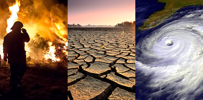
So what is the buildup of carbon dioxide leading to? As stated before, it is leading to an expansion of the greenhouse effect, and the expansion of the greenhouse effect is leading to climate change. Climate change's effects can be seen everywhere, and the biggest effect of climate change is global warming. Global warming is responsible for the melting of polar ice caps, increase in dire-weather events, floods, droughts, rising sea-levels, and much more, harming both humans and animals.
So what can be done to eliminate climate change?
At this point, not much. Greenhouse gases have such long life cycles, and even if the whole earth were to stop moving (i.e. no human activity) carbon dioxide and other greenhouse gases would continue to have their heating effect on the atmosphere for a very long time.
Nonetheless, climate change can be combatted in the following ways: awareness and adaptation.
Awareness is important because when more people work for a cause, more happens. The more people know about climate change, the better. Adaptation is important because we cannot reverse climate change at this point as explained above. So we must learn to live with it, finding ways around the problems that it will continue impose on us.
Image result for climate change


Remote Sensing: Weather Satellites

Remote sensing is defined as the science of identifying, observing, and measuring an object without coming into direct contact with it. Remote Sensing originated when photography came about. It was going on for a while until it was first introduced in 1960 by Evelyn L. Pruitt of the U.S. Office of Naval Research. A satellite would detect and measure radiation of different wavelengths reflected or emitted from distant objects or materials. This data is sent to earth and computer systems translate it to an image.

Types of Remote Sensing:
Passive instruments only perceive radiation that is detected by natural energy.
Active instruments come with their own sources of EM energy and therefore are able to give light to the object of focus.

A satellite is a moon, planet or machine that orbits a planet or star. There are many types of satellites that are used to provide data for forecasting. Meteorologists use visible satellite images, infrared satellite images, and water vapor satellite images the most.


Satellites are designed in a complex manner but they all share an antenna and a power source. To collect data to forecast the weather, meteorologists would mainly focus on the two main types of satellites: GOES and POES.
Related image- GOES stands for Geostationary Operational Environmental Satellite and they orbit the earth above its equator at an altitude about 36,000 km high.
-POES orbit at a lower altitude of about 850 km high and take an estimate of 100 minutes to travel from pole to pole.


Satellites are proven to save lives. COSPAS-SARSAT has been acknowledged for rescuing more than 27,000 lives

Wednesday, December 13, 2017

1931 China Floods

The 1931 China floods can be considered the deadliest natural disasters. 52 million people were affected by the floods. You can not even tally up the amount of damage that happened that occurred in central China. You also can not tally up the amount of deaths that are caused by his storm. Over 4 million died because of the flood and this is a loose approximation. The weather leading up to the flood was unusual. They had a severe drought from 1928-1930 and than an abnormally cold winter with heavy snow. In the summer of they experienced 7 cyclones, the normal amount is two per year.
Then the dams and dykes were abused and weak because the government was disorganized from constant attempts of evasion from the Japanese and internally there was not a established government. So the weak dykes and dams were not able to contain the sudden increase in water levels and broke. All of central China was flooded. The inundations were constant and wiped out all of China's crops. Many people died because of disease and famine then the inundations itself. The situation was so bad that people resorted to cannibalism for food. It took many years for China to recover from this horrific event. China didn't build a complete dam until 2009. This was because the rivers kept breaking the dams and dykes. The 1931 China floods show us we need to be prepared for disasters and we need to keep track of our environment.
Image result for 1931 china floods

Climatology

Climatology

Climatology is the field of meteorology that focuses on the study of climate and changes in climate. In other words, climatology can be defined as the study of weather patterns of a specific location in the atmosphere over a long period of time. The actual study of climate has existed on earth for a very long time, specifically since the 9th century. The first person to ever bring about the idea of studying earth's atmospheric movements or climate, in general, was a Chinese scientist named Shen Kuo. Shen Kuo was born in 1031 in the Hangzhou province of China and was a well-known mathematician, astronomer, and inventor. He is known for being the first scientist in history to physically study earth’s climate and record it. He would later die in Zhengzhou, China in 1095.
Image result for shen kuo
Shen Kuo
Climatology focuses on the “collective state of the atmosphere”. This means that when you study climatology, you focus on many “collective” factors, in other words, the different measures that hinder climate. The study of climatology is focused on the “Normal”. This means that it focuses on the average conditions of a specific location over a long period of time, typically 30 years. Climatologists use these 30 years to anticipate the conditions of the atmosphere in that range. For example, it is 2017, so climatologists can predict atmospheric conditions in December of this year using the conditions of December 1887.  Climatology studies the factors that influence weather/ the conditions of a location that drive it to have the type of climate that it has.
The field of climatology focuses on improving life for living beings around the world. Climatologists inform people how to minimize pollution and help maintain a climate that is healthy and safe enough for living organisms to thrive. Climatology also helps in understanding what changes in earth's atmosphere mean and what effect they have to the people living on earth. The study of climate also helps in determining future long-term atmospheric conditions at any given time. Long-term weather patterns give information that is helpful to the government and people in general so that they can be prepared for what is to come. Climatology also aids in important things like aviation, transAtlantic and transPacific travel by water, farming, determining the rising and falling of tides, and so on. Without climatology, the world will be amounted to a ticking time bomb, in other words, no one will know what happens next.

Monday, December 11, 2017

Hurricane Charley

Hurricane Charley

Hurricane Charley was a strong storm which caused a lot of destruction. Grand Cayman Island, Cuba, Florida, and South Carolina were the places affected by hurricane Charly. Charley developed from a tropical wave that moved off the coast of Africa on August 4, 2004. On August 9, while located 115 miles southeast of Barbados, the system strengthened to become a tropical depression. It continued into the Caribbean Sea and became Tropical Storm Charley the next day. A strong ridge of high pressure caused the storm to turn northwest on August 11, about 90 miles south of Kingston, Jamaica. The hurricane intensified to Category 2 strength after passing 15 miles northeast of Grand Cayman Island. The hurricane further strengthened to Category 3 status just before making landfall over western Cuba early on August 13 with winds of 120 mph. The storm went from a hurricane with winds of 110 mph to one with 145 mph winds in just 3 hours. Charley then turned more towards the northeast and continued to strengthen, reaching Category 4 status with winds of 150 mph. Hurricane Charley made a lot of destruction. The hurricane did about 16.3 million dollars in damages and about 11,000 houses were damaged or destroyed. Hurricane Charley made landfall in Florida within 24 hours of Tropical Storm Bonnie this was the first time two tropical cyclones made landfall in one state within a single day.


Image result for hurricane charley

Heat Wave 1936

On the summer of 1936 happened the deadliest heat wave of U.S history. With 5000 people dead, the great heat wave was divided into two phases, the first one was formed on July 6th. It began on North Midwest and moved northeast to Southern Ontario and hit eight states on U.S ( IL, IN, IA, MI, MN, MO, WI, OH ), leaving a total of 3959 fatalities. This wave was destroyed on 16th of July when a cold front moved into that region and scoured all the hot air, but at the same day the heat reloaded on Southern Midwest and moved down to the South and West of  U.S, this was a much longer ( until late August ) and intense heat wave, but not that successful since the geographical area that it hit was much more urbanized. The Great Heat Wave of 1936, set up many all time records of temperature in US, counting 15 states for that. It also set up records as the warmest summer since 1895, with an average of 74.6 degrees Fahrenheit and July as the single warmest month ever recorded with a mean of 77.4 degrees Fahrenheit.
Related image

Sunday, December 3, 2017

Blizzard of 1888

The Blizzard of 1888, which to date is one of the deadliest snowstorms to hit the United States, formed on March 11. Eerily enough, temperatures on March 10–just a day before the storm hit—were in the mid-50’s in the Northeast. That all changed on March 11, when cold Arctic air from Canada collided with Gulf air from the south and temperatures collided. Rain turned to snow and winds reached hurricane-strength. New yorkers were about a week away from spring; no one expected a sudden drop in temperature, let alone snow.

The snowstorm was categorized as a blizzard: a storm with winds of more than 35 miles per hour and snow that limits visibility to 500 feet or less. A severe blizzard is defined as having winds exceeding 45 miles an hour, and temperatures of 10 degrees fahrenheit or lower.  The blizzard of 1888, indeed, was labeled as a severe blizzard. The national weather service estimated that fifty inches of snow fell in Connecticut and Massachusetts and forty inches covered New York and New Jersey. Winds blew up to 48 miles an hour, creating snowdrifts forty to fifty feet high.

New york was the state that was affected most by this storm. More than 400 lives were taken away and 25 million dollars in property damage resulted. Telegraph and telephone wires snapped when they could no longer sustain the weight of the snow and ice, in effect isolating New York, Boston, Philadelphia, and Washington for many days. Two hundred ships sunk, and at least one hundred seamen died.
In conclusion, this was one of the worst blizzards in American history that struck the Northeast. This blizzard is remembered most for the snow that it released on the East Coast. Two reasons why this blizzard was so odd and unique was firstly because most severe winter storms that affect the Northeast are caused by an outbreak of cold air across the eastern U.S. No such air mass was in place prior to the development of the storm. Secondly, the storm center became stationary and actually made a counterclockwise loop off the coast of southern New England. Despite the tragedies, meteorologists found these atmospheric conditions fascinating and still do!


Friday, December 1, 2017

George Hadley

        George Hadley was born on February 12, 1685 in London, England. He was known as an English physicist and a meteorologist. He was elected as a fellow of the royal society. Meaning he helped improved natural knowledge. Hadley was the one who made the first study of trade winds. His life as meteorologist was interesting and he was an amateur at the time. Hadley suggested the atmospheric mechanism by which the trade winds are uninterrupted. This is known as the Hadley circulation. The trade winds are winds that prevail through most of the tropics, blowing mostly from the northeast from the northern hemisphere and the southeast from the southern hemisphere. Trade winds help sailors move from place to place because without it, they would float. It also helps planes take off but if planes takeoff into the wind then it would cost more fuel. George Hadley died on June 28, 1768.
Image result for george hadley death