The Dust Bowl lasted from 1934 to 1937 and it was also called “Dirty Thirties”. It was located in the Great Plains region in the USA which consisted of Oklahoma,Texas, Kansas, Colorado, and New Mexico. The storm was so bad it wrecked and destroyed everything it came in contact with. About 60 percent of the people fled and traveled west. By the time 1940 had come 2.5 million people had left the regions affected by the Dust Bowl. The jet stream played a big role in Dust bowl. Cooler than normal tropical Pacific Ocean temperatures and warmer than normal tropical Atlantic Ocean temperatures contributed to a weakened low level jet stream and changed its course. The jet stream normally flows westward over the Gulf of Mexico and then turns northward pulling up moisture and dumping rain onto the Great Plains. But during the 1930s the low level jet stream weakened, carrying less moisture, and shifted further south. The Great Plains land dried up and dust storms blew across the U.S. Another reason is because during World War 1 farmers grew more crops for military troops. In order to make more space for the crops the farmers plowed and tore the grass that kept the soil stable. As soon as the drought hit and there was no more water the soil turned to sand. Since the soil lacked a strong root system of grass as an anchor the winds easily picked up the loose topsoil and swirled it around into dense dust clouds, which are known as “black blizzards.” The exact number of deaths from the Dust Bowl remains unknown but some sources suggests hundreds, even thousands, of Plains residents died from exposure to dust. Alexandre Hogue was a famous painter who painted during this time period and showed others what he saw through his paintings.
Sunday, November 20, 2016
Saturday, November 19, 2016
Joanne Simpson

Joanne Simpson was born March 23, 1920 in Boston Massachusetts, United States and died March 4, 2010 in Wshington D.C..She received her undergraduate and graduate degrees from the University of Chicago in 1949. She also received She became the first woman to earn a Ph.D. in meteorology in the same year. After graduating from the university of Chicago, Joanne came to NASA Goddard as the Chief of the Severe Storms Branch of NASA’s Laboratory for Atmosphere, in 1979. She spend time on researchers on convective cloud systems, hot towers, cloud models and many observations of tropical cyclones. She made essential contributions to several historic NASA field missions, including the Convection And Moisture experiment missions like the Tropical Ocean Global Atmospheres,, the GARP Atlantic Tropical Experiment and many others. In 1986, Joanne led the science study for the proposed Tropical Rainfall Measuring Mission (TRMM). Between 1986 and November 1997, Joanne served as Study Scientist in the first place and then Project Scientist for TRMM, this is really usable today. In fact, one of joanne Simpson greatest discoveries was the hurricane heat engine. Its brings energy from the ocean surface to the clouds high above, driving the storm’s awesome power. Hot towers are something where she puts some work in, a hot tower is a tropical cumulonimbus cloud that penetrates the tropopause. The cloud top breaches in the top of troposphere, and reach the stratosphere. She developed the first cloud model, she also discovered what makes a hurricanes run and reveals what drives the atmospheric currents in the tropics. During her 40s and 50s, She conducted some unique “weather modification” experiments that have an impact on meteorology today. She expands more opportunities to women and to new meteorologists in general.
Saturday, November 12, 2016
Lewis Fry Richardson
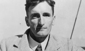
Lewis Fry Richardson was born October 11, 1881, Newcastle upon Tyne, Northumberland, Eng.—died Sept. 30, 1953, Kilmun, Argyll, Scot. Lewis Fry Richardson was the youngest of seven children. He went to Newcastle Preparatory School, and his favorite subject was Euclid. In 1894, Lewis was sent to Bootham in York, a school for the sons of wealthy Quakers. Lewis then studied at Durham College of Science. He completed his studies at Cambridge University with a First Class degree in the Natural Science Tripos in 1903. Other meteorologist of Lewis’s time made weather predictions based off historical schemes. Lewis however set out to calculate the weather. He made his first forecast in 1922. He built a mathematical model of the Earth’s atmosphere based on physical rules. He wrote mathematical equations for quantities like the change in air pressure in relation to winds. He would then input pressure, wind velocity, temperature and other variables. His experiment failed. Lewis realized his failure was because he didn't take into account turbulence. Turbulence knocked the air out of predictable paths by sending eddies of air up, down or sideways. After further research he realized the turbulence was caused by the ratio of heat energy to wind energy. Although his research on turbulence was considered a success, his forecasting method was considered a failure. That was until technology capable of quickly doing his complex equations was invented. His numerical process became the standard for forecasting. Today his method is the basis for weather forecasts and climate modeling.
Thursday, November 10, 2016
Hurricane Sandy
Hurricane Sandy lasted from October 22, 2012 until November 2, 2012. It struck some areas in the Caribbean including Bermuda, the Bahamas, the Greater Antilles, the eastern coast of the U.S. including Delaware, Maryland, Virginia, Pennsylvania, New Jersey, New York, Vermont, New Hampshire, Massachusetts, Connecticut, Rhode Island, Maine, and then some parts of eastern Canada. The hurricane originated from a tropical wave in warm ocean waters. Hurricane Sandy was drawn westward by an unusual bend in the jet stream. This jet stream bended northward over eastern North America. This change is caused by the presence of a strong high-pressured cell, called a blocking high, that stops moving over Greenland and any eastward movement of storms behind the blocking high slows down substantially. Then a cold air mass with a low pressure center approached the hurricane’s warmer counterclockwise wind field, the winds circulated around the low pressure centers of the cold air mass and of Hurricane Sandy began to mix. This interaction pulled part of the cold air mass to the south of the hurricane and turned the jet stream separating the two systems westward, which drew Hurricane Sandy toward the New Jersey coast After the cold air mixed with the warm air of the hurricane, both systems came together. This merging caused the hurricane to become a extratropical cyclone, renamed by the National Hurricane Center as the Post-Tropical Cyclone Sandy, but referred to as Superstorm Sandy by meteorologists and newscasters. Hurricane Sandy killed over 200 people, about 80 deaths in the Caribbean and the rest happening in the United States. There was $315 million worth of damage in the Caribbean and $62 billion worth of damage in the U.S.
http://www.rsmas.miami.edu/blog/2012/10/28/hurricane-sandy-prepping-for-frankenstorm-transformation/sandy_vis_sat/
- I wanted to paste a picture, but my computer didn't let me so I put the link of the picture I wanted to post.
http://www.rsmas.miami.edu/blog/2012/10/28/hurricane-sandy-prepping-for-frankenstorm-transformation/sandy_vis_sat/
- I wanted to paste a picture, but my computer didn't let me so I put the link of the picture I wanted to post.
Tuesday, November 8, 2016
Guy Stewart Callendar
Callendar was born in February 1897, Montreal, Canada. Callendar was the second son of Victoria Mary Stewart and physicist hugh Longbourne callendar. Callendar was introduced to science and technology as a young person because his parents were rich. Callendar Identified in 1938, the link between the artificial production of carbon dioxide and global warming, later called the Callendar Effect. He collected world temperature measurements and suggested that this warming was related to carbon dioxide emissions. He was one of Britain’s leading engineers, author of the standard reference book of tables and charts on the properties of steam at high temperatures and pressures. Callendar focused on research into batteries and fuel cells and expanded on the work of several 19th century scientists. In 1938, he compiled measurements of temperature from the 29th century on, and correlated it with the old measurements of atmosphere of atmospheric CO2 concentration. He concluded that over fifty years global land and temperature had increased and could be explained as an effect of the increase in carbon dioxide. Callendar most significant and original scientific contribution was in climatology. His dominant opinion was that at current atmospheric concentrations carbon dioxide already absorbed all the available long-wave radiation. Therefore any increase would not change the radiative heat balance of the planet but might augment plant growth. His papers convinced some other scientists of the need to conduct an organised research programme on CO2 concentration in the atmosphere leading to Mauna Loa measurements which proved pivotal to advancing the theory of anthropogenic global warming.
Sunday, November 6, 2016
El Niño of 2015
The 2015-2016 El Nino Event
My presentation was based of off the El Niño event between 2015-2016. El Niño refers to a periodic shift in the ocean and atmosphere that pushes west winds and warm water across the tropical Pacific, toward South America. El Niño develops about every 2 to 6 years. A classic El Niño event will intensify during the northern fall, peak in the winter and decrease in the spring. The most recent El Niño is considered to be in the top 3 El Niño events in the past few decades.The El Niño of 2015 formed during February- April 2015 period and finished on May 24, 2016. The winter of 2015-2016 was sold as the Godzilla of all El Nino's. El Nino's affected vulnerable people in parts of Eastern and Southern Africa, Asia and the Pacific, the Dry Corridor in Central America, and Haiti in the Caribbean. This event cause long term consequences for public health, nutrition, livelihoods, water and sanitation.The weather phenomenon has resulted in poor or failed harvests in Africa, the Pacific and Central America in mid-2016, and has forced millions of poor households to resort to negative coping mechanisms, such as reducing meal sizes and non-food expenditures and selling productive assets. In Kenya, the United Nations Children’s Fund is warning that up to 11 million children in east and southern Africa are at risk from hunger, disease and water shortages as a result of this year’s strengthening El Niño weather phenomenon. Kenya and Uganda are bracing for floods, while South Africa and Malawi are already grappling with drought. During an El Niño event, east African countries tend to have heavy rainfall, while southern Africa, along with Australia and Indonesia, usually experiences dryness, even drought and wildfires.
My presentation was based of off the El Niño event between 2015-2016. El Niño refers to a periodic shift in the ocean and atmosphere that pushes west winds and warm water across the tropical Pacific, toward South America. El Niño develops about every 2 to 6 years. A classic El Niño event will intensify during the northern fall, peak in the winter and decrease in the spring. The most recent El Niño is considered to be in the top 3 El Niño events in the past few decades.The El Niño of 2015 formed during February- April 2015 period and finished on May 24, 2016. The winter of 2015-2016 was sold as the Godzilla of all El Nino's. El Nino's affected vulnerable people in parts of Eastern and Southern Africa, Asia and the Pacific, the Dry Corridor in Central America, and Haiti in the Caribbean. This event cause long term consequences for public health, nutrition, livelihoods, water and sanitation.The weather phenomenon has resulted in poor or failed harvests in Africa, the Pacific and Central America in mid-2016, and has forced millions of poor households to resort to negative coping mechanisms, such as reducing meal sizes and non-food expenditures and selling productive assets. In Kenya, the United Nations Children’s Fund is warning that up to 11 million children in east and southern Africa are at risk from hunger, disease and water shortages as a result of this year’s strengthening El Niño weather phenomenon. Kenya and Uganda are bracing for floods, while South Africa and Malawi are already grappling with drought. During an El Niño event, east African countries tend to have heavy rainfall, while southern Africa, along with Australia and Indonesia, usually experiences dryness, even drought and wildfires.
Subscribe to:
Posts (Atom)