
Tuesday, December 13, 2016
Hurricane Sandy
Hurricane Sandy is a storm which resulted in at least 177 mortalities, damaged at least 200,000 homes, affected at least 8 billion people with power outages, and even resulted in more than $50 billion in cost of damaged things. This storm originated off the west coast of Africa as a minor tropical wave. This wave then became classified as a tropical depression in the southern Caribbean. Sandy then started moving up north to Jamaica and developed an eye. As Sandy crossed Jamaica, her wind speeds reached up to 90 mph. The storm then left Jamaica and started to head towards Cuba. Once she reached landfall− an arrival at land on a sea− her wind speed was up to 105 mph. This turned her into a Category 2 hurricane; however, the storm soon decreased its speed and power after it lost its eye when it interacted with Cuba’s cordillera− a group of parallel mountains. After leaving Cuba, Sandy turned into a hybrid storm and then an extratropical cyclone. After this, Hurricane Sandy made its way up north and affected the U.S. East Coast. Ways that it affected the East Coast were by flooding the street, ripping away home and boardwalks, eroding the beaches and dunes, and even closing the NY Stock Exchange, which rarely ever happens. Overall, this storm was definitely one of the strongest that the United States ever experienced.
Project Acceleration: Climatology in North America

Climate change can be tied to many of the problems and changes in the world today, from problems with health care and the job market to the environment itself. Climate change is deteriorating our current environments morphing and changing them, destroying many environments, and in some special cases creating new environments.Climate change has come to affect the lives of many beings including but not exclusively affecting humans. Although there are some natural causes that do tend to change the world's climate such as changes in the sun's energy and shifts in ocean currents, these alone do not explain the abnormal warming that we have observed over the last half-century .The global average temperature has increased by more than 1.5°F since the late 1800s, and other regions of the world have heated up to even twice that amount. The extent of these changes depends on how much and how quickly the greenhouse gas emissions can be reduced, If the arctic is able to recover its lost ice, and if the global conveyor belt is able to regulate the temperatures. Global warming is expected to continue to intensify. Affecting things like California's water problems, The Great Plains struggles with farming, The constant changes in the North East, the increase in sea level, and the melting of permafrost.
California is currently in a drought, for the mountain snow pack providing nearly a third of California's water supply is melting too quickly in the summer months for snowfall to compensate in the winter months. The population in California alone makes it hard to secure stable sources of drinking water, its naturally arid climate does not help either. The Great Plains has a distinct east-west gradient in average precipitation, with eastern Texas and Oklahoma experiencing more than 50 inches per year, while some of Montana, Wyoming, and western Texas receive less than 15 inches per year. While warmer temperatures are appearing faster in the Great Plains and are staying longer and the rainfall has shown no signs of increasing. Effectively creating desert like landscapes. The Northeast has seen such a jump in precipitation rates because of the oceans high temperatures in the fall and transitional winter seasons these warmer and wetter conditions that are now found in the north for longer periods of time are projected to aid in the eventual warming of 4.5°F to 10°F by the 2080s. Sea level rise and coastal flooding are likely to disrupt and damage important infrastructure, including communication systems, energy production, transportation, waste management, and access to clean water, The constant rising of the ocean waters and the growth of shore lines mostly due to the constant melting of ice in the arctics. While the melting of permafrost adds to the already abundant and deadly greenhouse gasses.
Climate change can prove to be our end and we as people of the world will regret our actions when it is too late to change them.
Hurricane Andew
Hurricane Andrew
Hurricane Andrew is considered to be one of the most devastating storms in recent history. Hurricane Andrew wreaked havoc on the Bahamas, southern Florida, and even central Louisiana in late August of 1992. During that time Hurricane Andrew was considered to be one of the most expensive hurricanes that hit the United States. It was the strongest hurricane to hit Florida in decades. The ferocious hurricane cost the United States over twenty-five billion dollars in damage. Hurricane Andrew formed near Cape Verde in the east Atlantic Ocean and from there it moved towards the west. It was classified as a category four hurricane when it reached Eleuthera Island in the Bahamas. The impact of the hurricane caused a twenty-three foot storm surge that devastated the nearby Current Island. Hurricane Andrew was able to move faster than average hurricanes because of its very small diameter. It reached South Florida in a matter of days. In mid-August of 1992 in the Atlantic, Hurricane Andrew was born. Hurricane Andrew started out as very insignificant storm that most people assumed will fall apart. Like any other hurricane, Andrew started off as a tropical wave. A tropical wave is generally a slow-moving disturbance that's embedded in the easterly trade winds. Hurricane Andrew was created by a tropical wave that crossed from the west coast of Africa until it reached the North Atlantic Ocean.There were ten people who fell victim to the wrath of the ferocious Hurricane Andrew in Dade County, and there were at least three victims in the Bahamas. Not only did the violent hurricane take the lives of over a dozen people, but it also knocked power out in over one million households, and altered the very region of South Dade. The eye of Hurricane Andrew reached the shore of Florida City, which is only twenty-five miles south of downtown Miami, around five o’clock in the morning. The gales of Hurricane Andrew were up to one-hundred-sixty-eight miles per hour. The worst damage occurred from Kendall south to Florida City. The government was forced to implement a curfew law from dusk till dawn in order to restrict looters from stealing from others. The damage was more significant here because the eye-wall is the home of the most dangerous winds of a hurricane. The winds moved at great and high speeds and greatly damaged what it encountered. The damage to Louisiana alone cost nearly one billion dollars. The damage in the Bahamas was a quarter of the damage in Louisiana. The damage in the Gulf of Mexico is estimated to be around half of a billion dollars. Andrew was able to whip up powerful seas that caused even more extensive damage offshore. Hurricane Andrew caused so much damage and chaos, so the name was retired. Usually the names of hurricanes are only retired when the hurricane is extremely destructive. This was the case for Hurricane Andrew. It is still among the top ten hurricanes in American history.
Monday, December 12, 2016
Hurricane Iniki
Hurricane Iniki
On September 11, 1992, Hurricane Iniki hit Kauai, Hawaii at a massive speed. Iniki killed 6 people and affected over 14,000 homes. Its wind speeds went up to 130 mph putting this hurricane as a category 4 on the Saffir-Simpson Scale. The Saffir-Simpson Scale is a scale that categorizes a hurricane's intensity class by its wind speeds, with category 5 being the highest. Hurricane Iniki costed up to $3 billion dollars in damage. They also interrupted the last day of filming for Steven Spielberg's Jurassic Park. The whole entire film crew was trapped inside their hotel In Oahu but were able to record some footage of the storm itself. Hurricanes in Hawaii are a very rare occurrence. This is due to 4 main protective factors. These factors are a high pressure factor, cold water, dry and stable air, and wind shear. These all push any upcoming disasters away from Hawaii.
Unfortunately Iniki broke through and hit Hawaii hard. Iniki is the forth hurricane Hawaii has ever had and it remains the most destructive. Hurricane Iniki formed in Africa and rapidly traveled to Hawaii with so much force allowing it to break through the four protective factors. People to this day are frightened of this hurricane and since Hawaii rarely gets them, they never know when or how to expect and deal with an upcoming disaster.
Project Acceleration: Hurricane Katrina
 Hurricane Katrina was one the most deadly hurricanes to ever hit the USA. It first formed 200 miles southeast of the Bahamas on Aug 23, 2005. It was first said to be a tropical depression according to the NOAA. The next morning a band of storm clouds started to wrap around the north side of the storm’s circulation center. The wind at this time was about 40 mph, the storm was then named Tropical storm Katrina. On Aug 25 Katrina was a moderate category 1 hurricane heading into southern Florida. After hitting Florida hurricane Katrina stalled beneath a very large upper-level anti cyclone that dominated the entire Gulf of Mexico, and Katrina gained strength. On Aug 26 Katrina re-intensified and on Aug 28 with winds at about 175 mph making it a category 5 hurricane. The hurricane weakened to a category 3 before making landfall along the Louisiana-Mississippi border on Aug 29.It was weakened to a category 1 hurricane after moving inland over southern and central Mississippi and then an became extra tropical low on Aug 31. Hurricane Katrina caused major flooding leaving many people homeless.
Even though Katrina caused so much destruction scientists were able to learn from it and improve science. “Around the time of Katrina, scientists thought the presence of "hot towers"— tall thunderstorm clouds that carry a lot of heat upward— could increase the intensity of a hurricane. Since Katrina, scientists have been learning that it's not necessarily whether these deep towers of clouds are present or not, but where the drafts of rising air, or updrafts, are positioned in great quantity and in specific locations inside of the cyclone”(Patel, 2015).
Cleveland Abbe
Cleveland Abbe
Cleveland Abbe was born December 3, 1838 – Died October 28, 1916. He was born in New York, to a prosperous merchant family. His Father was George Waldo Abbe was a wealthy merchant and philanthropist. As a child, he attended the David B. Scott Grammar School. In 1857 he graduated from the New York Free Academy. In 1860 he received a master's degree. In 1864 he received a degree from Harvard. In 1871, Abbe was appointed chief meteorologist at the United States Weather Bureau. Abbe was the expert responsible for coordinating a team to predict the weather. Abbe demanded precise language to make sure every forecast covered 4 key meteorological elements:
weather , temperature, wind direction, and barometric pressure. By 1872, Abbe regularly sent over 500 sets of daily maps and bulletins overseas. Without Cleveland Abbe weather stations would not have consistent times. In 1879 he divided the United States into 4 different time zones. In 1883 he convinced the North American railroad to adopt his time zone system. The American Government soon adopted the time zones. In 1884 Britain helped him gather international consent for a global time. Abbe wanted the weather service to stay at the forefront of technology. The Weather service headquarters tested thousands of instruments for quality. By the end of the century, self-registering equipment came into use, and the United States led the meteorological world with 114 observation stations. Cleveland Abbe’s many contributions were important. He was a model for what would become the National weather service. He created time zones for North America so weather predictions could be more time accurate. He improved the technology of the time for more accurate weather predictions.
Sunday, December 11, 2016
The Tri-State Tornado
The Tri- State Tornado
The Tri-State tornado formed on March 18, 1925. Tornadoes form when different temperatures and humidity meet. Generally, warm air rises. When the two fronts meet, the cold air can trap the warm air beneath it. Because the warm air cannot move upward, it begins to rotate. As the sun heats the ground, more warm air continues to rise, until finally the mass is strong enough to push through the cold air barrier. The rising warm air pushes the cold air beneath it, creating a rotating column that can span up to 10 miles, while twisting at speeds exceeding 200 mph The tornado went through three different states, hence the name "Tri". The tornado originated in southeastern Missouri. Then it traveled through southern Illinois. And finally it made its way into southwestern Indiana. Illinois was the hardest-hit area in the tornado’s path, with 234 deaths. There were over 2000 survivors who were left injured. The winds of the tornado were roughly 300 miles per hour. The width of the tornado was one mile. The average speed was 62 miles per hour and it reached a peak of 73 miles per hour. The tornado was even classified as a F5 tornado on the Fujita scale. The Tri State Tornado holds a series of records. It is the longest tornado track in the United States (219 miles). It has the most deaths in a single tornado (695). It also has the most injuries in a single tornado (2027). It even has the longest tornado duration (3.5 hours). It is widely considered to be the second deadliest tornado in world history/ It is also one of the largest and fastest tornadoes in United States history. A man in Parrish, Il. survived the tornado by clinging to a railroad track while the town was destroyed. In West Frankfort, Il. a farmer found a barber chair from some other town, and a bond. A man in Griffin, IN reported that he grabbed a door-handle and the house blew away, leaving the door handle with him. A popcorn man in Murphysboro, Il. was reportedly tossed up in the air “to the height of a one story building” then set back down a block away. His popcorn stand moved three feet and was still on it’s wheels.Sunday, December 4, 2016
William Ferrel

William Ferrel was born in January 29, 1817 Fulton county, Southern Pennsylvania. He was an american meteorologist. His family moved to west Virginia in 1829. His formal elementary schooling was limited and he taught himself using science books well enough to become a school teacher. He attended Marshall College and despite financial difficulties, he was able to graduate from Bethany College's first graduating class in 1844. Ferrel began his career as a scientist and he concentrated on tidal theory. Ferrel extended the non harmonic developments of the tide-producing potential beyond the points reached by Laplace and Lubbock and demonstrated that it is the tendency of rising warm air, as it rotates due to the Coriolis effect, to pull in air from more southerly, warmer regions and transport it pole ward, and for that It is this rotation which creates the complex curvatures in the frontal systems separating the cooler Arctic air to the north from the warmer continental tropical air to the south. He developed theories which explained the mid-latitude atmospheric circulation cell in detail, and it is after him that the Ferrel cell was named. Ferrel cell explained that the air flows pole ward and eastward near the surface and equator ward and westward at higher altitudes this movement is the reverse of the airflow in the Hadley cell. Ferrel created the tide predicting machine and set it up to predict the ebb and flow of sea tides.
Sunday, November 20, 2016
The Dust Bowl
The Dust Bowl lasted from 1934 to 1937 and it was also called “Dirty Thirties”. It was located in the Great Plains region in the USA which consisted of Oklahoma,Texas, Kansas, Colorado, and New Mexico. The storm was so bad it wrecked and destroyed everything it came in contact with. About 60 percent of the people fled and traveled west. By the time 1940 had come 2.5 million people had left the regions affected by the Dust Bowl. The jet stream played a big role in Dust bowl. Cooler than normal tropical Pacific Ocean temperatures and warmer than normal tropical Atlantic Ocean temperatures contributed to a weakened low level jet stream and changed its course. The jet stream normally flows westward over the Gulf of Mexico and then turns northward pulling up moisture and dumping rain onto the Great Plains. But during the 1930s the low level jet stream weakened, carrying less moisture, and shifted further south. The Great Plains land dried up and dust storms blew across the U.S. Another reason is because during World War 1 farmers grew more crops for military troops. In order to make more space for the crops the farmers plowed and tore the grass that kept the soil stable. As soon as the drought hit and there was no more water the soil turned to sand. Since the soil lacked a strong root system of grass as an anchor the winds easily picked up the loose topsoil and swirled it around into dense dust clouds, which are known as “black blizzards.” The exact number of deaths from the Dust Bowl remains unknown but some sources suggests hundreds, even thousands, of Plains residents died from exposure to dust. Alexandre Hogue was a famous painter who painted during this time period and showed others what he saw through his paintings.
Saturday, November 19, 2016
Joanne Simpson

Joanne Simpson was born March 23, 1920 in Boston Massachusetts, United States and died March 4, 2010 in Wshington D.C..She received her undergraduate and graduate degrees from the University of Chicago in 1949. She also received She became the first woman to earn a Ph.D. in meteorology in the same year. After graduating from the university of Chicago, Joanne came to NASA Goddard as the Chief of the Severe Storms Branch of NASA’s Laboratory for Atmosphere, in 1979. She spend time on researchers on convective cloud systems, hot towers, cloud models and many observations of tropical cyclones. She made essential contributions to several historic NASA field missions, including the Convection And Moisture experiment missions like the Tropical Ocean Global Atmospheres,, the GARP Atlantic Tropical Experiment and many others. In 1986, Joanne led the science study for the proposed Tropical Rainfall Measuring Mission (TRMM). Between 1986 and November 1997, Joanne served as Study Scientist in the first place and then Project Scientist for TRMM, this is really usable today. In fact, one of joanne Simpson greatest discoveries was the hurricane heat engine. Its brings energy from the ocean surface to the clouds high above, driving the storm’s awesome power. Hot towers are something where she puts some work in, a hot tower is a tropical cumulonimbus cloud that penetrates the tropopause. The cloud top breaches in the top of troposphere, and reach the stratosphere. She developed the first cloud model, she also discovered what makes a hurricanes run and reveals what drives the atmospheric currents in the tropics. During her 40s and 50s, She conducted some unique “weather modification” experiments that have an impact on meteorology today. She expands more opportunities to women and to new meteorologists in general.
Saturday, November 12, 2016
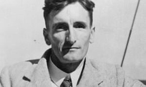
Lewis Fry Richardson
Lewis Fry Richardson was born October 11, 1881, Newcastle upon Tyne, Northumberland, Eng.—died Sept. 30, 1953, Kilmun, Argyll, Scot. Lewis Fry Richardson was the youngest of seven children. He went to Newcastle Preparatory School, and his favorite subject was Euclid. In 1894, Lewis was sent to Bootham in York, a school for the sons of wealthy Quakers. Lewis then studied at Durham College of Science. He completed his studies at Cambridge University with a First Class degree in the Natural Science Tripos in 1903. Other meteorologist of Lewis’s time made weather predictions based off historical schemes. Lewis however set out to calculate the weather. He made his first forecast in 1922. He built a mathematical model of the Earth’s atmosphere based on physical rules. He wrote mathematical equations for quantities like the change in air pressure in relation to winds. He would then input pressure, wind velocity, temperature and other variables. His experiment failed. Lewis realized his failure was because he didn't take into account turbulence. Turbulence knocked the air out of predictable paths by sending eddies of air up, down or sideways. After further research he realized the turbulence was caused by the ratio of heat energy to wind energy. Although his research on turbulence was considered a success, his forecasting method was considered a failure. That was until technology capable of quickly doing his complex equations was invented. His numerical process became the standard for forecasting. Today his method is the basis for weather forecasts and climate modeling.
Thursday, November 10, 2016
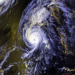
Hurricane Sandy
Hurricane Sandy lasted from October 22, 2012 until November 2, 2012. It struck some areas in the Caribbean including Bermuda, the Bahamas, the Greater Antilles, the eastern coast of the U.S. including Delaware, Maryland, Virginia, Pennsylvania, New Jersey, New York, Vermont, New Hampshire, Massachusetts, Connecticut, Rhode Island, Maine, and then some parts of eastern Canada. The hurricane originated from a tropical wave in warm ocean waters. Hurricane Sandy was drawn westward by an unusual bend in the jet stream. This jet stream bended northward over eastern North America. This change is caused by the presence of a strong high-pressured cell, called a blocking high, that stops moving over Greenland and any eastward movement of storms behind the blocking high slows down substantially. Then a cold air mass with a low pressure center approached the hurricane’s warmer counterclockwise wind field, the winds circulated around the low pressure centers of the cold air mass and of Hurricane Sandy began to mix. This interaction pulled part of the cold air mass to the south of the hurricane and turned the jet stream separating the two systems westward, which drew Hurricane Sandy toward the New Jersey coast After the cold air mixed with the warm air of the hurricane, both systems came together. This merging caused the hurricane to become a extratropical cyclone, renamed by the National Hurricane Center as the Post-Tropical Cyclone Sandy, but referred to as Superstorm Sandy by meteorologists and newscasters. Hurricane Sandy killed over 200 people, about 80 deaths in the Caribbean and the rest happening in the United States. There was $315 million worth of damage in the Caribbean and $62 billion worth of damage in the U.S.
http://www.rsmas.miami.edu/blog/2012/10/28/hurricane-sandy-prepping-for-frankenstorm-transformation/sandy_vis_sat/
- I wanted to paste a picture, but my computer didn't let me so I put the link of the picture I wanted to post.
http://www.rsmas.miami.edu/blog/2012/10/28/hurricane-sandy-prepping-for-frankenstorm-transformation/sandy_vis_sat/
- I wanted to paste a picture, but my computer didn't let me so I put the link of the picture I wanted to post.
Tuesday, November 8, 2016
Guy Stewart Callendar
Callendar was born in February 1897, Montreal, Canada. Callendar was the second son of Victoria Mary Stewart and physicist hugh Longbourne callendar. Callendar was introduced to science and technology as a young person because his parents were rich. Callendar Identified in 1938, the link between the artificial production of carbon dioxide and global warming, later called the Callendar Effect. He collected world temperature measurements and suggested that this warming was related to carbon dioxide emissions. He was one of Britain’s leading engineers, author of the standard reference book of tables and charts on the properties of steam at high temperatures and pressures. Callendar focused on research into batteries and fuel cells and expanded on the work of several 19th century scientists. In 1938, he compiled measurements of temperature from the 29th century on, and correlated it with the old measurements of atmosphere of atmospheric CO2 concentration. He concluded that over fifty years global land and temperature had increased and could be explained as an effect of the increase in carbon dioxide. Callendar most significant and original scientific contribution was in climatology. His dominant opinion was that at current atmospheric concentrations carbon dioxide already absorbed all the available long-wave radiation. Therefore any increase would not change the radiative heat balance of the planet but might augment plant growth. His papers convinced some other scientists of the need to conduct an organised research programme on CO2 concentration in the atmosphere leading to Mauna Loa measurements which proved pivotal to advancing the theory of anthropogenic global warming.
Sunday, November 6, 2016
El Niño of 2015
The 2015-2016 El Nino Event
My presentation was based of off the El Niño event between 2015-2016. El Niño refers to a periodic shift in the ocean and atmosphere that pushes west winds and warm water across the tropical Pacific, toward South America. El Niño develops about every 2 to 6 years. A classic El Niño event will intensify during the northern fall, peak in the winter and decrease in the spring. The most recent El Niño is considered to be in the top 3 El Niño events in the past few decades.The El Niño of 2015 formed during February- April 2015 period and finished on May 24, 2016. The winter of 2015-2016 was sold as the Godzilla of all El Nino's. El Nino's affected vulnerable people in parts of Eastern and Southern Africa, Asia and the Pacific, the Dry Corridor in Central America, and Haiti in the Caribbean. This event cause long term consequences for public health, nutrition, livelihoods, water and sanitation.The weather phenomenon has resulted in poor or failed harvests in Africa, the Pacific and Central America in mid-2016, and has forced millions of poor households to resort to negative coping mechanisms, such as reducing meal sizes and non-food expenditures and selling productive assets. In Kenya, the United Nations Children’s Fund is warning that up to 11 million children in east and southern Africa are at risk from hunger, disease and water shortages as a result of this year’s strengthening El Niño weather phenomenon. Kenya and Uganda are bracing for floods, while South Africa and Malawi are already grappling with drought. During an El Niño event, east African countries tend to have heavy rainfall, while southern Africa, along with Australia and Indonesia, usually experiences dryness, even drought and wildfires.
My presentation was based of off the El Niño event between 2015-2016. El Niño refers to a periodic shift in the ocean and atmosphere that pushes west winds and warm water across the tropical Pacific, toward South America. El Niño develops about every 2 to 6 years. A classic El Niño event will intensify during the northern fall, peak in the winter and decrease in the spring. The most recent El Niño is considered to be in the top 3 El Niño events in the past few decades.The El Niño of 2015 formed during February- April 2015 period and finished on May 24, 2016. The winter of 2015-2016 was sold as the Godzilla of all El Nino's. El Nino's affected vulnerable people in parts of Eastern and Southern Africa, Asia and the Pacific, the Dry Corridor in Central America, and Haiti in the Caribbean. This event cause long term consequences for public health, nutrition, livelihoods, water and sanitation.The weather phenomenon has resulted in poor or failed harvests in Africa, the Pacific and Central America in mid-2016, and has forced millions of poor households to resort to negative coping mechanisms, such as reducing meal sizes and non-food expenditures and selling productive assets. In Kenya, the United Nations Children’s Fund is warning that up to 11 million children in east and southern Africa are at risk from hunger, disease and water shortages as a result of this year’s strengthening El Niño weather phenomenon. Kenya and Uganda are bracing for floods, while South Africa and Malawi are already grappling with drought. During an El Niño event, east African countries tend to have heavy rainfall, while southern Africa, along with Australia and Indonesia, usually experiences dryness, even drought and wildfires.
Monday, October 31, 2016
The European heat wave in 2003
The European Heat Wave 2003
The European heat wave of 2003 was the hottest summer on Europe since 1540. The heat wave led to many crisis in several countries and combined with drought to create crop shortfalls in parts of Southern Europe. There were many people effected by the wave which led to about 35,000 deaths. During the heat wave, rivers and lakes in parts of Serbia where lowered and 215,000 forest were destroyed by forest fires. Europe has taken action from this heat wave and set up alarm systems for the elderly living alone, and Europe has made connections with the Heat-Health watch, which gives a warning either the day before or the day of about hot weather.
The European heat wave of 2003 was the hottest summer on Europe since 1540. The heat wave led to many crisis in several countries and combined with drought to create crop shortfalls in parts of Southern Europe. There were many people effected by the wave which led to about 35,000 deaths. During the heat wave, rivers and lakes in parts of Serbia where lowered and 215,000 forest were destroyed by forest fires. Europe has taken action from this heat wave and set up alarm systems for the elderly living alone, and Europe has made connections with the Heat-Health watch, which gives a warning either the day before or the day of about hot weather.
Sunday, October 30, 2016
George Hadley
My presentation was on the famous Meteorologist, George Hadley. George Hadley was the creator of the Hadley Cell. The Hadley cell is simply explained as a giant conveyer belt of the atmospheric movement on earth. Cold and hot air are recycled, so whatever cold or warm air you feel now was cold or hot once before changed temperature depending on the location. The Hadley cell also explains why at the equator there are greens, meaning rainforests, and deserts as it gets farther away. This has to do with warm air rising and creating precipitation, which is heavier at the equator and it makes good conditions for rainforests.
Sunday, October 23, 2016
Jim Cantore
My presentation was about Jim Cantore. He is an American meteorologist from White River Junction, VT. He graduated from Lyndon State College in 1986. That same year he landed his first internship and job at The Weather Channel. It was here that he made a name for himself and ultimately celebritize meteorology. He is known for his enthusiastic and tenacious style of reporting. He also possesses an ability to translate complicated language into simple terms that anyone can understand. Jim has appeared on numerous tv shows and sports broadcasts. He is also is an advocate for preparedness and is an enthusiast of thundersnow.

A year without Summer in 1816
My presentation was on the year without Summer in 1816. North America and Europe were the countries that faced the devastating temperatures. It all started because of a eruption by Mount Tambora which shot out volcanic ash into the atmosphere, 38 cubic miles of ash. Since the volcanic ash went into the atmosphere it covered solar radiation from hitting the surface which prevented the earth from getting warm. Farmers in North America and Europe weren't able to produce crops because of the cold weather and heavy rains. So people were starving and had to rebel and fight for food. Bakeries and food markets were getting robbed and people moved out of their villages to search for some type of food. People were dying from starvation, Cholera, and freezing temperatures. The only good thing that came out of this disaster was the invention of the laufmaschine and the help of creating the books Frankenstein and The Vampyre.

Subscribe to:
Posts (Atom)