Sunshine is delicious, rain is refreshing, wind braces us up, snow is exhilarating; there is really no such thing as bad weather, only different kinds of good weather. ~John Ruskin

Monday, September 27, 2021

Hurricane Sandy

 Hurricane Sandy

  Superstorm Sandy also known as Hurricane Sandy or Post Tropical Cyclone Sandy was a massive storm that damaged many places. It damaged Jamaica, Cuba, Haiti, DR and the Bahamas as well as U.S Mid-Atlantic Northeastern states. This happened in late October 2012.

Sandy began as a tropical wave in the warm ocean waters of the central part of the tropical North Atlantic on October 19. The system traveled west into the Caribbean sea during the next few days and was classified as a tropical depression by the NHC (National Hurricane Center) on October 22 while in the waters south of Jamaica. As it went northward, the depression grew into a tropical storm and the NHC named it Sandy.

On October 24, with sustained 80 mile (about 130 km) per hour winds, Sandy became a category 1 hurricane in the waters just south of Jamaica. After its maximum sustained winds increased to more than 90 miles (144 km) per hour during the late evening, NHC officials reclassified the storm as a category 2 hurricane. Shortly after midnight on October 25, Sandy’s winds rose to 110 miles (177 km) per hour, and by dawn the eye had passed over eastern Jamaica and eastern Cuba.

Between October 25 and October 28, Sandy continued northward but declined in intensity, and it was reclassified as a category 1 hurricane and later as a tropical storm; after passing over The Bahamas and paralleling the coastline of the southeastern United States, the storm had again grown into a category 1 hurricane. On October 29 the storm curved westward toward the Mid-Atlantic states, and by 8:00 PM it made landfall near Atlantic City, New Jersey, with maximum sustained winds of 80 miles (about 129 km) per hour.


Sandy's Journey:


Gabriel Fahrenheit

 Gabriel Fahrenheit was born May 24, 1686 in Danzig, Poland, and spent most his life in the Netherlands where he devoted himself to physics and manufacturing meteorology instruments. He visited other places to learn new skills on making instruments. In 1714 he came up with the mercury thermometer which at the time was a huge accomplishment. He used his invention to develop the first temperature scale precise enough to become a worldwide standard. He was the author of important improvements in the construction of thermometers, and he introduced the thermometric scale known by his name.


Monday, September 20, 2021

Godfather of the clouds- Luke Howard


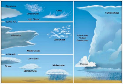
    Luke Howard was the man who named and classified all of the clouds we know and study today.  he gave three base classifications Cumulus- for heap of clouds, they are the large fluffy ones we see a lot, Cirrus- thin wispy clouds which are often seen in clear sky's and stratus are the large sheets of clouds on days when they sky is completely white and covered in clouds. Luke lived long enough for his work become mainstream the terms we use are the same from 200 years ago given by him. 

Today: Luke Howard birthday — 28 November 1772 — he gave clouds their names  - Dull Men's Club

Friday, September 17, 2021

Joplin Tornado

    The Joplin tornado was an EF5 on the Fujita scale. It tore through 6 miles and was almost a mile wide and caused a tremendous amount of damage. As you can see below:


    Since it was covered by high-precipitation cells they couldn't even tell the tornado was coming until 15 minutes before it touched the ground. Due to the late notice and the intensity of this tornado, it was extremely dangerous. So dangerous that it was named the most dangerous tornado to ever be recorded in the US. There were 161 deaths and more than 1,000 injuries making it the deadliest tornado to be ever recorded in US history. A little over 8,000 buildings in all were damaged, most were totally destroyed or destroyed beyond repair. The total damage cost was over 3 billion dollars. After the tornado was over Joplin, Missouri was devastated. They needed to rebuild after the tornado. NIST who focuses on American innovation and industrial competitiveness went to Joplin a couple days after the tornado to examine and collect data. From this, they were able to help Joplin build safer homes that would be more resistant to tornadoes along with hospitals too. They also wanted to install tornado shelters in every house and lastly, they wanted more clear nation codes and communications in emergencies like this.


Monday, September 13, 2021

Who is Mr. Tornado?

     Mr. Tornado was a famous Japanese-American meteorologist and college professor by the name of Tetsuya "Ted" Fujita. He was an expert in the field of natural disasters. From hurricanes to tornadoes to typhoons to any other natural disaster, Fujita knew it all. But, as you can tell by the title Fujita is commonly known for his groundbreaking research on tornadoes. 

    
    Before the world knew about Dr. Fujita and his expertise on tornadoes, his first big event was the aftermath of Hiroshima and Nagasaki. Fujita didn't think like the average meteorologist/scientist. He would account for the factors that most would regard as irrelevant and the angles that others simply didn't know about. Fujita was able to find out the strength of the atom bomb, the height at which it exploded, and several other important factors. 
    Dr. Fujita later came to America to continue his research on tornadoes and teach at the University of Chicago. Though Fujita had been an expert in tornadoes for over 30 years, he never actually saw a tornado until he was in his 60's. Just like in Hiroshima and Nagasaki, Fujita paid attention to the damage done by the tornado and the debris that was left of it. He was able to find out the strength, size, and so many other aspects of the tornadoes, which led to a scale still used today called the "Fujita Scale." 
Dr. Fujita's greatest contributions to meteorology
  • Fujita created a scale (pictured above) that determined the strength of a tornado, known as the "Fujita Scale" which is still used today. The scale is based on the speed of the tornado, from least to the greatest threat. F0-F5
  • Fujita also saved thousands of lives with the discovery of microbursts, which were the downdraft of tornadoes. These microbursts could wreak havoc on anything in their path especially planes in the air. (Pictured above is damage done by a microburst to an airport)
What lesson can be learned from Dr. Fujita?
  • Always case or assess a situation/event/problem/etc., inch by inch from all the angles. Try to account for the factors that others ignore or regard as irrelevant.

Dr./Prof. Tetsuya "Ted" Fujita 
1920-1998


The Camp Fire of 2018

 The Camp Fire of 2018 was the deadliest and expensive fire in Californian history. The fire burned over 150,00 acres in northern California during November 2018. 

The fire was started by a damaged electrical cable in Butte County in North California near Camp Creek Road. The fire spread quickly due to the drought conditions in the mountainous brush of the Sierra Nevada and the high winds of the late dry season. The fire incinerated the nearby towns like Paradise and Concow as it merged with a separate fire to grow even larger. The fire reddened the sky and lowered the air quality across Western America as well as some places in the East.

When the smoke cleared, massive amounts of property and forestry were decimated. Many cities saw significant population dips after the fire and many communities are smaller because of it. No major climate change legislation was passed under Former President Donald Trump because of the fire. President Joe Biden has created a Climate Task Force and invested in green energy to combat climate change. No major policy changes were made at the state level, either.

The Camp Fire of 2018 killed 85 people and left damage that is yet to be repaired in its wake. Sadly, fires of this magnitude seem to be just as the United Nations said, 'the new normal'.

Friday, April 16, 2021

The Mariana Trench- Environmental Science

The Mariana Trench is a deep-sea trench located on the floor of the western North Pacific Ocean. This trench is regarded as the deepest point on Earth. It is part of the western Pacific system of oceanic trenches coinciding with nearby subduction zones. 

The Mariana Trench stretches for more than 1,580 miles (2,540 km) with a mean width of 43 miles (69 km) The trench’s deepest points are reached in Challenger Deep, on the floor of the main trench southwest of Guam. Nobody has ever made it to the bottom of the trench, but the greatest depths were reached by Victor Vescovo in 2019 at 35,853 feet or 6.7 miles.

Due to the deep depths, there is very little to no sunlight in parts of The Mariana Trench and there is extreme pressure the deeper you go, life is still very much present and interesting. The trench is home to many deep-sea creatures such as the Seadevil Anglerfish, Goblin Shark, and Zombie Worms to name a few.  Sadly there are also many signs of plastic debris floating around deep in the trench, with some even being found inside of certain species’.

The pressure at Mariana Trench is 1000 times greater than the sea level's atmospheric pressure.
Mariana Trench's ocean floor has a yellowish color to it due to all of the decaying plants and animals.
If you could place the highest mountain in the world, Mount Everest, at Challenger Deep of Mariana Trench, its peak would still be over 2 kilometers below sea level. As many as 200 microorganisms have been identified at Mariana Trench.


Tuesday, March 16, 2021

The Endangered Species Act (Environmental Science)

    The Endangered Species Act was passed and instituted in 1973. This act was seen as key legislation for both domestic and international conservation. The act is aimed to provide a framework to conserve and protect endangered and threatened species and their habitats. The goal of this act was to protect all species threatened with extinction that fall within the borders of the United States and its other territories. 

    The Endangered Species Act allows authorities to determine whether a given species is qualified for endangered or threatened status. According to the USFWS, the “species” definition also extends to subspecies or any distinct population segment capable of interbreeding. This means that certain subsets of a species may also be singled out for protection. If granted the status of “Endangered”,  the act prevents unauthorized harvest, custody, trade, and transport of the species. (Plants, animals, and other at-risk organisms). The act allows for the application of civil and criminal penalties upon those who violate this law.

    To regulate the Endangered Species Act there are different organizations that watch over each area of the environment. For example, the U.S. Fish and Wildlife Service (USFWS) of the Department of the Interior and the National Oceanic and Atmospheric Administration (NOAA) of the Department of Commerce is responsible for the conservation and management of endangered fish and wildlife resources and their habitats. With this role an organization has, comes the power to establish cooperative agreements with and award monetary grants to the states to provide protection for at-risk organisms within their borders. States are offered financial assistance and incentives to develop and maintain these organizations, 

    Modest Trump Admin Reforms Could End Worst Abuses of Endangered Species Act  – InsideSources


Friday, February 12, 2021

United States Radium Corporation

    The U.S. Radium Corp. is a radiation site located in Orange, New Jersey. This site was used to operate a radium processing plant from 1917-1926. During its operation, waste generated from the plant was disposed of both on and off the property of the facility. This waste contaminated the site and local properties with radium-226. 

    Radium-226 is a highly radioactive isotope with a half-life of 1600 years. Radium-226 emits ionizing radiation and decays into radon gas. When directly exposed to people, the radioactive dust particles can be inhaled or ingested, causing adverse health effects with an increased chance for certain types of cancer. The United States Radium Corporation was used to extract and process radium from carnotite ore. 

    The extracted radium was then sold and used for medical purposes and luminous paint. This luminous paint was especially in high demand for dials, watches, and aircraft instruments painted with luminescence paint. During its operation, about a half-ton of carnotite ore was processed each day. In 1926, the U.S. Radium Corporation ceased its extraction and processing. 

    The United States Radium Corporation employed around 100 workers, and about 70 of them were women. While working on the smaller number dials on thee watches, the owners of the company told the women to use their mouths to point the brush. Though there somewhat was an understanding of radium’s dangers, these women still used their mouths to help themselves paint on the dials. Due to the high volumes of radiation being this close to their mouths, many of these women began to suffer from diseases, such as anemia, bone fractures, and necrosis of the jaw, (radium jaw). Today these women are known as the ‘Radium Dial Girls’


    When New Jersey officials came to the realization of the dangers this level of radiation may cause in the early 1980s, they took immediate actions to protect both human health and the environment. In September 1983, the EPA placed the site on the Superfund programs National Priorities List.  Following this, between 1989 and 1993, the EPA completed a broader remedial investigation and feasibility study, further assessing the level of contamination in the area. In 1991, the EPA took interim removal actions in an attempt to mitigate the radiation’s threat to human health and the environment.


Saturday, December 12, 2020

Satellites

    According to Nasa.gov, a satellite is a moon, planet or machine that orbits a planet or star. With this definition of a satellite, we can also consider the planets in our solar system, like the Earth, a satellite since it orbits the sun. These are known as “Natural Satellites.” More specifically, a "satellite" refers to a machine that is launched into space and revolves around Earth or another body in space. These machines are used by various different researchers to help better understand the universe.

    Some meteorologists use satellites to take pictures of the planet in order to predict weather and track hurricanes. Other meteorologists take pictures of other planets, the sun, black holes, dark matter, or faraway galaxies. Many other satellites are still used mainly for communications, such as beaming TV signals and phone calls around the world.

    Satellites are able to give researchers a bird's-eye view allowing them to see large areas of Earth at one time. This ability allows satellites to collect more data even quicker than instruments on the ground. Satellites are also very useful because they can provide much clearer images of outer space than telescopes. This is because they reside above the natural barriers like clouds and dust molecules that can block the view from the ground level.  Satellites are also used to make TV signals and phone calls possible. These devices are able to send their signals up to the satellite, which almost instantly sends them back down to different locations on Earth.

    Out of the 2,666 operational satellites circling the globe in April 2020, 1,007 were for communication services. 446 of these satellites are used for observing the Earth and 97 for navigation/ GPS purposes. Right now, there are nearly 6,000 satellites circling our tiny planet. About 60% of those are defunct satellites or space junk, and roughly 40% are operational.


Sunday, December 6, 2020

El Nino and La Nina

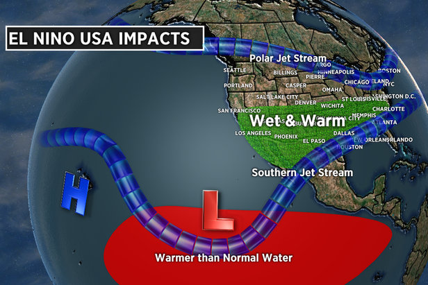
 La Nina and El Nino are both effects that occur because of the El Nino Southern Oscillation phenomena El Nino being a warm phase and La Nina is the cold phase with a neutral phase occurring occasionally in between. The El Nino Southern Oscillation also is known as ESNA is a pattern of trade winds in the Pacific Ocean that influence the weather across the world. The name El Nino (little boy) was fixated on this event when waters would be warmer than normal on the coast of South America and La Nina (little girl) was for when the waters would be colder than normal. During an El Nino, which occur every 3-5 years, there is is a warming of waters in the Pacfic Ocean that is paired with stronger winds that blow eastward. The effects that come with El Ninos include a drastic increase in rain levels in the southern United States, that often bring flash floods. Along with this there are often colder winters in the northeast due to a strong polar jet from the north. El Ninos also have a strong impact on hurricane formation and during an El Nino event there is an increase in hurricane production in the Pacfic Ocean and a decrease in the Atlantic Ocean due to the strong wind shear that often rips apart any tropical activity. 

During a La Nina the effects are the opposite of an El Nino, the waters in the Pacfic Ocean cool while and the wind slows down. During a La Nina the southern United States is met with extremely hot and dry weather, while the northern states often deal with above average precipitation during the winter months. Likewise with La Ninas there is an impact on hurricane production but differing to El Ninos, La Ninas produce more hurricanes in the Atlantic and less in the Pacific due to the water and wind changes. ESNO is referred to as one of the most important weather phenomena across the globe because of the heavy impact that it has on food and agriculture sources across the world. The cause behind this event includes oceanic circulation which involves the rising and sinking of warm and cold waters throughout the oceans on the planet. One particularly grim event involved an El Nino during the years 2015-16 in which over 60 million people were directly impacted due to the years El Nino, which caused widespread famine, drought, and disease outbreak. With the warming of our planet these El Ninos will continue to gain strength and impact more and more people across the world. 


Monday, November 30, 2020

Radiosondes & Rawinsondes

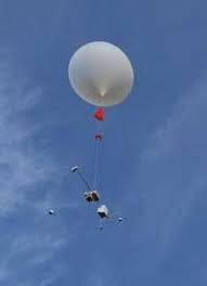
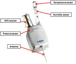
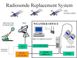
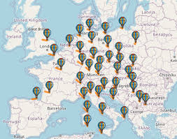
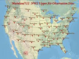
       Radiosondes are small, expendable instrument packages that are suspended below a large balloon inflated with hydrogen or helium gas known as the weather balloon. They transmit air pressure, temperature, relative humidity, and GPS position data each second they are used. They are also connected to a battery-powered, 300 milliwatt radio transmitter so they transfer their data much faster.

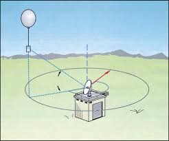
    Rawinsondes are observations where winds aloft and are obtained by radiosondes. They can be radiosondes or can be a result of radiosonde data but they work the same as radiosondes but are tracked by a radar or radio direction finder. It can project methods of upper-air observation consisting of an evaluation of wind speed and direction, temperature, pressure, and relative humidity.

When the balloon reaches its maximum height, it explodes leading the device to fall a large height from the atmosphere. However, there is an orange parachute to prevent this device from breaking due to it having a possibility to harming the environment and to possibly use these devices again in the future. Most radiosondes however land in the oceans due to most of the stations being on the coasts.

Without radiosondes, we wouldn't be able to calculate weather data to create maps, graphs, and future conditions. Without these devices, we wouldn't even know if it would rain or if there could be snow. This has a very important purpose in today's technology.

Monday, November 16, 2020

The Doppler Radar

 The Doppler radar is a modern weather radar that is used to see more than just clouds. It was named after J. Christian Doppler, who first proposed the idea of the "Doppler effect" when he noticed that a train horn was louder when stationary next to him compared to when it was moving away. The radar sends low frequency radio waves (pulses) into stormy areas to determine the velocity, distance, and direction of the wind or precipitation. It can also measure if the storm is moving away or towards the radar. A picture of it is shown below, containing a large satellite dish covered by a sphere to protect it from the elements.

    This forecasting process begins with a low frequency radio wave, or pulse, that is shot into a storm at a certain elevation. Once the pulse hits a raindrop, piece of hail, or a gust of wind the pulse breaks apart and many different waves shoot out in different directions. Using the Doppler effect, one wave will reach back to the satellite dish with a different frequency than what it started with. The back and forth interaction will usually last about 0.00000157 seconds. The forecasters can then measure the intensity of the storm by using the new frequency of the returning waves. If the pulse return with a high frequency, they can assume that the storm is intense, while a low frequency indicates a less powerful storm. The pulse also helps to find the horizontal distance of the storm, which is helpful in forecasting the storm on a map. The Doppler radar is important because it not only finds the distance of a storm, but it also finds the intensity. This can help predict future weather events and how detrimental they will be to certain areas. This can help communities properly prepare for any upcoming storms; whether it is closing windows of the house or evacuating.

    An example of the Doppler radar is the WSR-88D. Currently, it is the most powerful radar worldwide, possessing the strength of 750,000 watts. For perspective, this wave transmitter is 10,000 times more powerful than a lightbulb (75 watts). As most Doppler radars can only see one storm at a time, this model can see past more than one storm, giving information on further weather. The National Weather Service (NWS) owns one of these machines that sees 14 elevations every 5 minutes, giving one pulse every 20 seconds. This intelligent radar gives quick and accurate depictions on the weather, and what is to come.    

  1. the Doppler effect: an increase (or decrease) in the frequency of sound, light, or other waves as the source and observer move toward (or away from) each other. The effect causes the sudden change in pitch noticeable in a passing siren, as well as the redshift seen by astronomers. (Definition from Oxford Languages)

Thursday, November 12, 2020


Alvaro P. Paulin

Meteorology

Mrs. Tuorto

11/12/20

                                                                Guy Stewart Callendar


Guy Stewart Callendar was born on February 9, 1898 in the city of Montreal, Canada. He was born to the father Hugh Longbourne Callendar and the mother Victoria Mary Stewart.His father was an accomplished physicist who was the first to design and build an accurate platinum resistance thermometer suitable for use.  He received his primary education at Durston House, secondary education at St. Paul’s School and attended City and Guilds Engineering College (part of Imperial College), where his father was chair of the physics department. As a child, he lost his eye, which caused him to avoid going off to fight on the front lines in WWI he then went off to work with his father in a lab for the air ministry testing various apparatus and building aircraft engines. His home life provided a rich creative and technical environment where he was introduced to the scientific elite of England and was able to pursue his interests in science and engineering. In 1938 Callendar made a breakthrough discovery; he was able to detect that global temperatures were rising, and he was able to connect it to CO2 emissions. At the time this went widely unnoticed because "Scientists at the time also couldn't really believe that humans could impact such a large system as the climate - a problem that climate science still encounters from some people today, despite the compelling evidence to the contrary." Says Dr Ed Hawkins of the University of Reading. Here is a chart he used to show the correlation between the rise in CO2 gas and the rise in temperatures.


Works Cited

“." Complete Dictionary of Scientific Biography. . Encyclopedia.com. 16 Oct. 2020 .” Encyclopedia.com, Encyclopedia.com, 9 Nov. 2020, www.encyclopedia.com/science/dictionaries-thesauruses-pictures-and-press-releases/callendar-guy-stewart

Applegate, Zoe. “Guy Stewart Callendar: Global Warming Discovery Marked.” BBC News, BBC, 26 Apr. 2013, www.bbc.com/news/uk-england-norfolk-22283372

follow Guy Stewart Callendar on twitter!


                                                          Guy Stewart Calendar


Friday, November 6, 2020

Science Symposium: Hurricane Sandy

Isaiah Ramos                                                                                            11/6/2020

Meteorology                                                                                                Block 2

                                                      Hurricane Sandy

    Hurricane Sandy was by far the biggest hurricane of 2012, and one of the most destructive of the decade. It began as a tropical storm in the Caribbean on October 22. It then gradually developed into a Category 1 hurricane, hitting Jamaica with winds up to 80 mph. Sandy would then make landfall at Cuba with winds of 100 mph and developing into a Category 2 on October 25. For the next three days, Sandy would be heading northeast as a tropical storm, until reaching east of Virginia on October 29 and becoming Category 1. However, once it makes landfall at Atlantic City, New Jersey, it had already become an extratropical storm. What made it devastating was that it collided with a winter storm already in the area, becoming a large wintertime cyclone.

    I recall having to stay home because of Hurricane Sandy, and luckily my family was not heavily affected by it, we only lost power. However, families and their houses along the coast were likely destroyed or severely damaged based on how high the waves of this hurricane were. The hurricane finally died out on October 31, 2012, over Pennsylvania leaving large amounts of snow there. In New York City about 300 homes were destroyed and 44 lives were lost. The cost of all the damages and the general cost was 19 billion dollars. New York City looked for all of the emergency relief funding they could, but only received a total of 4.2 billion dollars. Overall, Hurricane Sandy had an everlasting impact by helping people realize how much climate change can affect the strength of the hurricane. Every year the numbers are constantly rising with the number of people afraid of global warming, but yet no major actions have yet to be taken. If no action is taken soon, there will be storms much worse than Sandy headed our way, I can guarantee it.

Superstorm Sandy | Path & Facts | Britannica

Tuesday, November 3, 2020

Gabriel Fahrenheit

 Zakei Shah

Mrs. Turoto

Meteorology 

Block II

                            Who Was Gabriel Fahrenheit?   


       Gabriel Fahrenheit was born in Gdańsk Poland and lost both his parents on the same day due to them consuming a poisonous mushroom. He turned to physics and became an instrument maker and glassblower. He traveled widely and spent a considerable amount of time in England where he became a member of the royal society. He created the mercury thermometer in 1714 and the alcohol thermometer in 1709. He developed the Fahrenheit temperature scale and the freezing and boiling point of water with atmospheric pressure. Fahrenheit is a temperature scale that bases the boiling point of water at 212 and the freezing point at 32. The scale is used primarily in the United States and some Caribbean countries. He created the temperature scale based on three fixed temperature points - that of freezing water, human body temperature, and the coldest point that he could repeatably cool a solution of water, ice, and kind of salt, ammonium chloride.

    Gabriel’s alcohol thermometer was the world’s first reliable thermometer. Unlike a mercury thermometer, the contents of an alcohol thermometer are less toxic and will evaporate quickly. The mercury thermometer was invented in 1714 with a standardized scale. The mercury thermometer was adapted so it could be taken out of the body to read the temperature. He made investigations based on the works of Guillaume Amontons, in which he determined the boiling point of water and other liquids and studied the expansion properties of mercury. The experiments led to the discovery that the boiling point of water varied with changes in atmospheric pressure. Gabriel was secretive and hid his methods of creating thermometers. He died in Holland on September 16, 1736.

Daniel Fahrenheit | Daniel Fahrenheit Facts | DK Find OutAlcohol Thermometer Vector Illustration. Temperature Measurement.. Royalty  Free Cliparts, Vectors, And Stock Illustration. Image 87817339.Thermometer Medical. A Glass Mercury Thermometer For Measuring.. Royalty  Free Cliparts, Vectors, And Stock Illustration. Image 77908504.


Gabriel Alcohol Mercury

Sites:

Complete Dictionary of Scientific Biography.  Encyclopedia.com. 16 Oct. 2020 URL: https://www.encyclopedia.com/people/history/historians-miscellaneous-biographies/daniel-gabriel-fahrenheit 

Daniel Gabriel Fahrenheit. Encyclopædia Britannica. URL: https://www.britannica.com/biography/Daniel-Gabriel-Fahrenheit 

Gabriel Daniel Fahrenheit facts. URL: https://biography.yourdictionary.com/gabriel-daniel-fahrenheit#:~:text=Born%20in%20Danzig%20on%20May,an%20instrument%20maker%20and%20glassblower

The Royal Society: 353 Years Later, England's First Scientific Organization Keeps On Illuminating. World science festival. URL: https://www.worldsciencefestival.com/2014/05/royal-society-353-years-later-englands-first-scientific-organization-keeps-illuminating/#:~:text=Officially%2C%20the%20Royal%20Society%20was,discuss%20scientific%20topics%20and%20watch 


Monday, October 26, 2020

Delta 191

 The Delta 191 flight on August 2nd, 1985, is the reason for weather delays in the present day. The Lockheed L-1011 TriStar with a total of 163 people on board departed from Fort Lauderdale, Texas, in hopes of reaching Los Angeles, California. Due to the lack of caution when it came to flying through extreme weather, the pilot lifted off disregarding the storm located right above the Los Angeles Airport. The ride was smooth until the plane approached it’s runway, and was unable to land due to the drastic winds that came with the storm. The plane was unable to fight against the harsh draft, and crashed into the ground. The aircraft gilded and slid on the ground, hitting an occupied car and ending up in the side of a water tank. There were 137 deaths and 26 injuries, one fatality being the driver of the struck car.

The cause of this iconic plane crash is known as a “Microburst”, also known as a downburst. These bursts of air usually last between 2-5 minutes, and can expand to about 2.5 miles(4 Kilometers). Before a microburst occurs, a downdraft must occur in the storm. After, air rises from below the clouds. Once the air reaches the clouds, it condenses and turns into water vapor. This adds to the cloud, and later leads to mass amounts of precipitation. Once the cold water droplets fall, they begin to lay pressure on the air below them. This air, after not being able to withstand the pressure, will begin to fall with the droplets, creating harsh winds that fall downwards, and begin to curve as they reach the ground. These winds can reach up to about 60mph when falling, and up to 100mph as they fan out to the side. This is a very rare occurrence in a storm, which makes this crash a historical moment, for the chances of the plane entering a microburst with such timing has chances of little to none.

 As shown in the picture below, the plane’s original trajectory towards the runway was no longer an option due to the microburst. The pilot attempted to predict the strength of the wind, as he began to bring the plane parallel with the ground. He underestimated the power of the downburst, as the plane just barely missed it’s runway.

- Ryan Johnsen